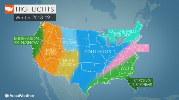
The return of an El Niño weather pattern will have a significant influence on the winter season.
Mild air will linger in the Northeast and mid-Atlantic before cold weather takes hold in January and February. Some Interstate-95 cities will notice a significant temperature dip compared to last year.
Meanwhile, an active southern storm track will send snow and ice to parts of the southern Plains this winter.
Once again, El Niño will influence the winter weather across the Northeast, mid-Atlantic and Great Lakes.
The season will start out mild for much of the region before colder weather digs in its heels in January and February.
“New York City and Philadelphia may wind up 4 to 8 degrees colder this February compared to last February,” AccuWeather Expert Long-Range Forecaster Paul Pastelok said.
In the mid-Atlantic states, a few big snowstorms are likely. Most of the action will dodge the far Northeast, however.
In the Great Lakes, lake-effect snow will be less frequent than normal, despite above-normal water temperatures. An uptick is possible in late winter, but, for the season as a whole, residents will receive less than they are accustomed to.
A very active winter is predicted for the Southeast, Tennessee Valley and Gulf Coast this season.
January and February will be particularly conducive to snow and ice threats, with multiple storms forecast for the region.
As cold shots become more frequent from mid- to late season, the central and western Gulf Coast will be susceptible to frost and freezes.
It will bear a stark contrast to the winter of 2017-2018, when February brought well above-normal temperatures to the area.
Come late winter, Florida will need to be on alert for severe weather and flooding.
Similar to areas farther east, the Midwestern states and central and northern Plains will enjoy a mild start to the season before cold outbreaks arrive later on.
January and February are predicted to bring a dramatic change in temperatures, Pastelok said.
Snowfall in these regions is likely to remain below normal, with storms occurring less frequently than usual.
“It won’t be a big year for snow in the major cities like Chicago and Minneapolis,” he added.
An active southern storm track will spell snow and ice events for parts of the southern Plains this winter.
While December could welcome a few storms, they are expected to become more frequent in January and February.
Areas from Dallas, and north of Houston, stretching into Little Rock will be susceptible.
Meanwhile, blasts of cold air could be problematic for area farmers.
“Anytime you get these deep shots of cold air like we’re calling for in the late season, there’s always a big threat in agricultural areas around central Texas,” Pastelok said.
“We’re worried there could be shots of cold getting down into the mid-20s in some places.”

