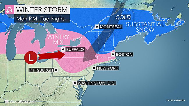
First winter storm of season to spread ice, snow across northeastern US next week
By Brett Rathbun, AccuWeather.com Meteorologist
December 26, 2015; 10:45 AM ET
A quick shot of cold air will allow an approaching storm system to bring a round of frozen precipitation across the northeastern United States early next week.
A storm system forecast to bring severe weather, ice and blizzard conditions across the south-central United States this weekend will track toward the Northeast late on Monday into Tuesday.
“Colder air moving into the Northeast will provide the setup for a wintry event early next week,” AccuWeather Senior Meteorologist Matt Rinde said.

Following rain this weekend, a cold front will push through the Northeastern states on Sunday night as a shot of colder, but seasonable air will set its sights on the region.
A strong area of high pressure will bring colder air down from southern Canada across the Northeast to begin the week.
As the storm tracks northward, the cold air near the surface will allow precipitation to start in the form of snow, sleet or freezing rain.
During the event, precipitation will transition from snow to ice to rain from the central portions of Pennsylvania into New England as milder air gets slowly drawn northward.
Many areas from central Pennsylvania to southwestern New York could start as a period of snow, sleet and freezing rain before changing over to rain.
Showers slip in on Saturday

“Significant snow and ice will be possible farther north from central New York to New England,” Rinde added.
Those heading to work on Tuesday morning should allow for extra time as roads could be icy and snow covered.
Precipitation along the Interstate 95 corridor from New York City to Washington, D.C., should just be in the form of rain as temperatures are expected to remain above freezing. However, the typically colder suburbs may begin with sleet or freezing rain before transitioning to rain.
The heaviest snow is likely to fall from upstate New York to northern New England where snowfall totals could approach 1 foot.
Where the areas of snow, ice and rain set up will depend on how much cold air is present and how quickly milder air builds northward.
Boston is likely to have its first accumulating snowfall this season Monday night into Tuesday before the precipitation changes over to rain.
Should a heavy amount of freezing rain occur in some areas versus sleet, there could be downed trees and power outages to contend with. Flight delays and cancellations will also be possible.
Milder air will rebuild behind this storm for the remainder of 2015.
