


Hazardous Weather Outlook – A strong coastal storm is expected to develop early next week
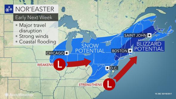
Hazardous Weather Outlook
National Weather Service Albany NY
335 AM EST Sat Mar 11 2017

CTZ001-013-NYZ043-049-050-052-053-059>061-064>066-084-VTZ015-121100-
Northern Litchfield-Southern Litchfield-Northern Washington-
Eastern Schenectady-Southern Saratoga-Eastern Albany-
Western Rensselaer-Eastern Greene-Western Columbia-Eastern Columbia-
Eastern Ulster-Western Dutchess-Eastern Dutchess-Southern Washington-
Eastern Windham-
335 AM EST Sat Mar 11 2017

This Hazardous Weather Outlook is for the Capital District,
Washington County, mid Hudson Valley, northwestern Connecticut and
the Connecticut River Valley of southern Vermont.

.DAY ONE...Today and Tonight.

Brisk and gusty winds are expected today especially during the
afternoon. If stronger wind gusts are expected then a wind advisory
will need to be issued.

.DAYS TWO THROUGH SEVEN...Sunday through Friday.

A strong coastal storm is expected to develop early next week.
Depending on the exact track of the storm, a potentially significant
amount of accumulating snowfall is possible over portions of the
region later Monday night into early Wednesday.

.SPOTTER INFORMATION STATEMENT...

Spotters are requested to send any wind measurements of 40 mph or
greater and or reports of wind damage to the National Weather
Service.

$$