
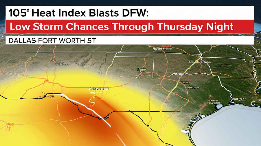
DALLAS-FORT WORTH, Texas – North Texas is enduring another period of sweltering heat and high humidity this week, with afternoon heat index values projected to soar as high as 105 degrees. While most of the region will face oppressive conditions, a slight chance of pop-up thunderstorms could disrupt outdoor plans through Thursday.
According to the National Weather Service in Fort Worth, temperatures are expected to remain in the 90s on both Wednesday and Thursday. However, the heat index – a measure of how hot it feels when humidity is factored in – will climb between 98 and 105 degrees across the Dallas-Fort Worth Metroplex, Waco, Sherman, and surrounding counties.
The forecast includes a slight risk of isolated, pop-up storms, particularly in the late afternoon and early evening. Areas such as Graham and Cisco face a higher chance, up to 30%, of experiencing these brief but intense downpours. These localized storms could bring sudden heavy rainfall, lightning, and gusty winds, with the potential for brief power outages.
While Graham and Cisco may see quick bursts of heavy rain, most of DFW, Sherman, Canton, and Waco are expected to contend primarily with scorching sun and extreme humidity. Outdoor events and work across the region may be disrupted by either the oppressive heat or sudden weather shifts.
Residents are strongly urged to take precautions against the heat: stay well-hydrated, limit strenuous outdoor activities during peak heat hours, and remain vigilant for rapidly changing weather conditions. Heat advisories may remain in effect through Thursday night, with more alerts possible if high heat index values persist or storm risks increase. The National Weather Service advises monitoring their updates for the latest information.


Leave a Reply