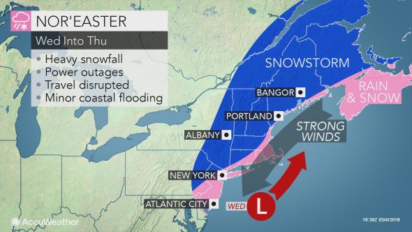
While the midweek storm may not become as powerful as the recent bomb cyclone, the northeastern United States can still face renewed power outages and widespread travel disruptions.
The storm set to unleash a blizzard over the northern Plains will fizzle over the eastern Great Lakes and the central Appalachians Tuesday into Tuesday night.
However, disruptions to travel and daily routines are expected to ramp up across the Northeast Wednesday into Thursday as the storm restrengthens along the coast.
Even if the storm fails to undergo rapid intensification, also known as bombogenesis, the Northeast will still face substantial snow, soaking rain and strong winds at midweek.

Compared to the recent bomb cyclone, impacts from the midweek storm are not expected to be as widespread across the mid-Atlantic. However, many areas that escaped the last storm’s wrath in northern New England may face the heaviest snowfall.
“The midweek storm may drop accumulating snow from The Delmarva Peninsula through Pennsylvania, New Jersey and into Maine and Quebec,” AccuWeather Senior Meteorologist Alan Reppert said. Enough snow to shovel, plow and disrupt daily routines is expected to fall.
“The heaviest snowfall may be in Vermont, New Hampshire and western Maine with over a foot of snow possible,” Reppert said.
The exact track of the storm will determine where the swath of disruptive snow will unfold versus rain or a wintry mix.
One scenario is for the storm to hug the coast close enough for most of the Interstate-95 corridor to experience plain rain or a mixture of rain and snow with the worst of the snowstorm occurring farther inland.
“This will lead to more coastal areas having just wet roadways with interior areas facing travel delays and dangerous travel,” Reppert said.
“Just north of New York City, Philadelphia and Boston, accumulating snow will cause travel disruptions for anyone commuting to the cities Wednesday into Thursday,” he said.
Roads may become slushy or slippery for a time even in these major cities if the snow comes down hard enough on the storm’s back side.

If the storm tracks farther offshore, more snow than rain can unfold along the I-95 corridor with mounting disruptions to travel and daily routines.
Regardless of which scenario pans out, the snow can be heavy and wet in nature just north of where rain is expected. In addition, winds will increase from the coast of New Jersey to Maine Wednesday into Thursday, but should fall well short of the peak gusts from last week.
Trees or power lines weakened late last week could still be brought down by either the heavy, wet snow or gusty winds.
Residents who get power restored early this week may find themselves back in the dark at midweek.
The strongest winds are expected to remain close to the coast and not renew the danger of damage across the rest of the mid-Atlantic. This includes in Baltimore and Washington, D.C.
Despite winds set to buffet the beaches, coastal flooding may not be as severe at midweek as during the bomb cyclone.
The quick-pace of the storm should limit any issues to minor problems for one or two high tides, especially in areas that suffered beach erosion the past few days.
Before the midweek storm arrives, coastal flooding in the wake of the bomb cyclone will continue to wane into Monday as the powerful storm finally departs.
However, the storm will first interact with another system to bring an inch or two of snow between Boston and Providence, Rhode Island, on Sunday night. Snow may also coat other parts of central and southern New England during this time.

Motorists should prepare for slushy roads and potential delays for the Monday morning commute.
The midweek storm may not be the last winter storm for the Northeast. Another storm may be brewing for around March 11-12.

